Description of the LAP-AUTh Air Quality Forecast System
Introduction
The LAP-AUTh air quality forecast system runs operationally in order to predict near surface air pollutants’ concentrations, mainly O3, NO2, CO, SO2 and PM10. Three-day air quality forecasts are issued on a daily basis, using a modeling system that consists of the Fifth Generation PSU/NCAR Mesoscale Model (MM5) and the Eulerian photochemical air quality model CAMx.
Modeling Domains
MM5 is implemented on two nested grids that share the same Lambert Conformal Conic projection. The first, coarse grid covers the South-East Mediterranean area and has a spatial resolution equal to 10-km. The second, fine grid has a higher spatial resolution (2-km) and focuses on the Greater Athens Area (GAA). Both grids have a vertical structure of 33 σ-levels, reaching at approximately 100 mbar height.
CAMx is also implemented on two nested grids, which have the same projection and spatial resolution with the corresponding MM5 grids. CAMx’s grids have 15 vertical layers extending up to approximately 7 km above ground level. The vertical layers are unevenly distributed with higher resolution at the near-surface layers. The first layer height is about 20 m.
Figure 1 depicts the modeling domains of the forecast system (Domain 2: Coarse grid, Domain 3: Fine grid).
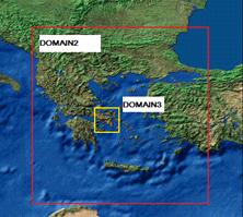
Fig.1: Modeling domains of the LAP-AUTh Air Quality Forecast System.
Figure 2 depicts the general flow chart of the forecast system.
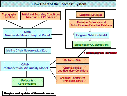
Fig.2: The LAP-AUTh Air Quality Forecast System flow chart.
Meteorology
The forecast system is driven by the meteorology provided by the Fifth Generation PSU/NCAR Mesoscale Model (MM5). MM5 is a limited area, non-hydrostatic, terrain following and sigma-coordinate model, designed to simulate and/or predict atmospheric circulation. The model consists of several pre- and post-processing programs which are referred to collectively as the MM5 modeling system.
The model develops Initial and Boundary Conditions (ICBC) based on the global 12 UTC forecast of GFS/NCEP that is characterized by a 1-degree spatial resolution. The forecast is transferred to the local infrastructure via an anonymous ftp client server and becomes available around 16 UTC. Interpolation of the available ICBC is carried out by the pre-processing program of MM5, REGRID.
Photochemistry
CAMx is an Eulerian, photochemical air quality model that simulates the emission, dispersion, chemical reactions and removal of pollutants in the troposphere, and it is thus extensively used in order to asses gaseous and particulate air pollution.
CAMx’s simulations are driven by the meteorology provided by MM5. The MM5toCAMx interface is implemented for linking the meteorological driver, MM5, with the air quality model, CAMx. The Carbon Bond (CB-IV) mechanism is implemented for solving chemical kinetics. The TUV radiative transfer and photolysis model is used as a CAMx preprocessor to provide the air quality model with a multi-dimensional lookup table of photolytic rates. The chemical boundary conditions are based on the European air quality forecast performed by NKUA in the framework of the EU project GEMS.
The anthropogenic emission data, used as CAMx input data, are gridded emission rates of gaseous pollutants (NOx, SO2, NMVOCs, CH4, NH3, CO) and particulate matter (PM10). Two emission inventories were compiled by LAP-AUTh, one for Greece (10km) and one for the GAA (2km). The development of the emission inventories was based on the methodologies of the EMEP/CORINAIR emissions inventory guidebook. All anthropogenic emission sources (industry, central heating, road transport, waste etc.) were taken into account in the inventories. Example maps of the calculated anthropogenic emission data can be seen in Figure 3. The emission data for all counties included in modeling other that Greece were taken from the EMEP emission database.
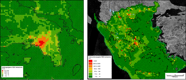
Fig. 3: Left: Total monthly anthropogenic VOCs emissions in the GAA (July), Right: Total annual anthropogenic PM10 emissions in Greece.
A biogenic emission model, totally coded in Fortran 90 and developed by LAP-AUTh, is implemented for calculating biogenic NMVOCs emissions (namely, isoprene, monoterpenes and OVOCs). The model integrates a variety of input data to estimate the biogenic NMVOCs fluxes on an hourly basis like: a) land use data, b) land-use-specific foliar biomass densities and emission potentials, derived from a database compiled by LAP-AUTh and c) MM5 forecasted temperature and solar radiation data. Figure 4 presents calculated biogenic NMVOCs emissions for the GAA domain.
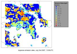
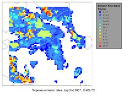
Fig. 4: Isoprene (left) and monoterpenes (right) hourly emission rates in the GAA
on the 2nd July 2007.